Recreational harvest of snook in Florida’s East Coast management regions will close June 1
Florida Fish and Wildlife Conservation Commission (FWC)
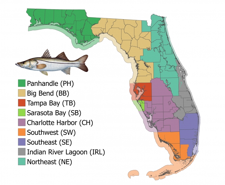
The recreational harvest of snook in Florida's Northeast, Indian River Lagoon and Southeast snook management regions (see map) will close June 1, 2024 and remain closed through August 31, 2024. This includes all Florida state and inland waters, as well as adjacent federal waters within each management region.
These regions and regulations are part of the FWC's holistic management approach for Florida's most popular inshore fisheries. Through this approach, seven metrics are used to evaluate the fishery by region, adding a holistic perspective to management decisions and allowing the FWC to be more responsive to regional concerns. To learn more, visit MyFWC.com/Snook.
For information on recreational snook regulations, visit MyFWC.com/Snook. This page includes the snook annual reviews that provide summaries of key findings from the annual evaluation of management metrics for each region.
Northeast Snook Management Region (aqua green on map - top right area):
Open season: February 1 – May 31 and September 1 – December 14
Closed season: December 15 – January 31 and June 1 – August 31
Bag limit: 1 fish per person per day
Slot limit: 28–32 inches total length
Boundaries: The northern coastal boundary is at the Florida-Georgia border and the region extends south to the Lytle Avenue/South Causeway in New Smyrna Beach. Includes all inland waters of the area colored yellow on the map, and the waters of the St. Johns River and its tributaries. Does not include the waters of the Withlacoochee and Kissimmee rivers, Cypress Lake, and lakes Hatchineha and Kissimmee.
Indian River Lagoon Snook Management Area (gray on map, right middle area):
Open season: February 1 – May 31 and September 1 – December 14
Closed season: December 15 – January 31 and June 1 – August 31
Bag limit: 1 fish per person per day
Slot limit: 28–32 inches total length
Boundaries: The northern coastal boundary is at Lytle Avenue/South Causeway in New Smyrna Beach and the region extends south to the Martin-Palm Beach county line. Includes all inland waters of the area colored yellow on the map, and all waters of the Kissimmee River, Lake Okeechobee and other lakes identified on the map with blue hatch. Does not include the waters of Loxahatchee and St. Johns rivers and their tributaries.
Southeast Snook Management Area (dark blue on map - lower right area):
Visit MyFWC.com/BNP to learn about the special regulations that apply to snook when fishing in Biscayne National Park.
Open season: February 1 – May 31 and September 1 – December 14
Closed season: December 15 – January 31 and June 1 – August 31
Bag limit: 1 fish per person per day
Slot limit: 28–32 inches total length
Boundaries: The northern boundary is the Martin-Palm Beach county line and the region extends south to the Miami-Dade/Monroe county line. Includes all inland waters of the area colored yellow on the map. Includes all waters of Hillsboro Canal, Miami Canal, North New River Canal, and West Palm Beach Canal, and the Loxahatchee River and its tributaries. Does not include Lake Okeechobee and Everglades National Park.
